By Frank Bucholtz, Peace Arch News contributor
Many aspects of White Rock make it unique, but one of the most enduring and everyday distinctions from its huge neighbour Surrey is street names.
Part of this is due to the fact that White Rock, in its earliest days as a city, decided to go in a completely opposite direction from Surrey and ensure that all streets had names. It is probably not coincidental that the movement towards names took place not long after Surrey had switched to mostly numbered streets. Some White Rock streets even had numbers for a short time after the city’s incorporation in April, 1957. All street names were completely restored by 1960, at the recommendation of a street naming committee.
In a few cases, well-known and familiar Surrey streets still carry their original names in White Rock – but not in Surrey. The two most prominent of these are Johnston and North Bluff roads, both of which have a deep history in Surrey. Others are Bergstrom, Nichol and Archibald roads. The only one of these road names with a historical South Surrey connection is North Bluff – named after the Ocean Park bluff which was first called “North Bluff” by Capt. George Vancouver.
The story behind street names in White Rock is fascinating. Most are named for people who lived there at one time or were prominent in the development of the community. Some are geographical. Some others were named as part of larger subdivisions. And a few are unique.
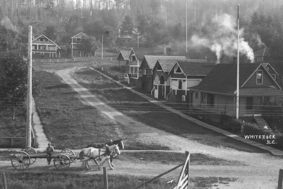
Let’s start at the beginning of the alphabet. White Rock was home to A to F Streets, which were given letter names as part of the first proposed subdivision in 1890. All of them now have names beginning with those letters (except for one). Most of these streets start at the waterfront and continue up the hill. In some places, they are simply paths along the rights-of-way.
From the east, A is Ash Street, B-Balsam, C-Cypress, D-Dolphin, E-Centre and F-Fir. These were given full names as part of the 1960 street naming recommendations. G was considered by that time to be part of the alphabetical group. It is now George Street.
Other street names which date back to the 1890 subdivision are Columbia Avenue, a main east-west street along the hillside, Victoria Avenue (named after the reigning monarch of the time), Pacific Avenue, Royal Avenue and Cliff Avenue.
The best-known street in White Rock is Marine Drive, but for most of White Rock’s early history, only part of what is now Marine carried that name. On the east end, it was known as Campbell River Road, a continuation of the road in Surrey that runs through the Hazelmere Valley. Along the waterfront, it was Washington Avenue, named for the principal street in neighbouring Blaine.
Only when it wound up the hill past High Street in western White Rock was it called Marine.
What is not well-known is the road along the beach was originally known as the sea front road and was built in colonial days by both British and American surveyors from 1856-61 to determine the exact location of the boundary between the U.S. and British territory. This road was taken over by the Great Northern Railway when it built its waterfront line into Canada, to replace the earlier rail line built in 1891 through the Hazelmere Valley. Washington Avenue was a replacement road built by the railway. The new rail line opened in 1909.
Henry T. Thrift, a Surrey pioneer who originally settled in Hazelmere, moved to White Rock in 1910 and lived there until his death in 1946. Buena Vista Avenue was named for the fine view from his home, which was called Bella Vista.
Thrift Avenue was originally the northern portion of his property, which was subdivided when the railway arrived in anticipation of summer settlers. The name was eventually extended to the entire length of the road, which runs from Oxford to Stayte.
Vidal Street is named after the Vidal family. Harry Vidal owned 20 waterfront acres which he subdivided prior to 1914. His wife Edith, almost universally known as Granny, was a mainstay in the community until her death in 1964 at the age of 98.
Other streets named after early White Rock families include Roper, Best, Oxenham, Russell, Kerfoot, Merklin and Goggs.
Elm Street, while less than a block long, is one of the best ways to picture early White Rock. It is the oldest inhabited street, other than the sea front road. Early cottage homes built in 1910 and 1911 and a quaint apartment building on the east side give it a character unlike any other part of the city. It was originally known as Subway Street, as the railway underpass was just across Washington. By 1918, its name was changed to Elm, marking plantings of elm trees in the area.
Another street with a botanical name is Maple Street, which goes back to the early years.
Brearley Street has an interesting background. Annie Brearley moved to White Rock in 1925 and established a fox farm. Her daughter Katherine attended school in White Rock, taught at Semiahmoo High, earned a doctorate and eventually lectured at UBC.
Coldicutt Avenue in western White Rock was part of the vast Coldicutt Villas property, about 600 acres with a half-mile of private beach. Tom Coldicutt ran a resort there, but it was just one of his many ventures. He had earlier been in the bus business and the shipping business.
Duprez Street is a short street off Marine Drive. It is named after Emile Dupraz (he was also known as Duprez), a native of France, who moved to White Rock in 1912. The Duprez Ravine at the north end of the street is home to trails leading up to Ruth Johnson Park.
Keil Street has an interesting wartime history. James Keil bought property and built a house about 1927. This led to the street naming. In 1941, the street sign was stolen. A letter writer to the Semiahmoo Sun, the local newspaper of the time, was pleased with this, claiming the name sounded too German. Keil was actually Scottish.
One unique street name is Cardinal Street. This short street was named at the suggestion of Ald. Gerry Holt, who noted that Bishop Street (named for the Bishop family) is nearby.
Two streets which evade attention deserve mention. Weatherby Street no longer exists. It was a short street off North Bluff. It was on property owned by Amy Weatherby, who moved to White Rock from the prairies in the 1940s. Expansion of Peace Arch Hospital eventually doomed the street, but ironically the hospital was situated there because she had donated five acres in 1951 for its construction. Her name lives on in a hospital pavilion.
Moffat Lane still exists, as a short lane off Pacific Avenue at the base of the steep hill. It is named for Bill Moffat, who was the chief of the Surrey Police in the 1940s, and had lived in White Rock since 1913. Prior to his police work he had been the engineer at the Campbell River lumber mill, which was on Semiahmoo First Nation land. Most of the site later became Semiahmoo Park.
The first human occupants of White Rock are not mentioned in any street names, with the exception of Semiahmoo Avenue, named for both the bay and the First Nation. It is located above Moffat Avenue and runs west to Centre Street.
Acknowledgements: Most of the information for this article comes from several excellent local history books: Years of Promise: White Rock 1858-1958 by Lorraine Ellenwood, Railway By the Bay, by Barrie Sanford, and Along The Way, by Margaret Lang Hastings.