Everyone’s familiar with the notion of a treasure map – but for White Rock author Derek Hayes, the real treasure is maps themselves.
In Hayes’ latest large and lavish tome, British Columbia: A New Historical Atlas (Douglas and McIntyre, $59.95), we see our home province emerge – map by lovingly reproduced map – from the mists of ignorance, imagination and assumption to resemble the geography we take for granted today.
Meticulous research and a thorough grasp of history has allowed Hayes to reconstruct the history of B.C. era by era in the colourful volume – from the best guesses of the Elizabethans to the evolution of our cities through the decades up to today.
A prolific author of map-based history books – his first, in 1999 received the Bill Duthie Booksellers Choice Award – Hayes has been influential in arguing that historic maps are not simply charts of a topography but guides back through time.
“My pet thing is that maps have not been utilized properly by historians,” said Hayes. “I think I’ve been trying to redress things by producing history books that consist of nothing but maps.”
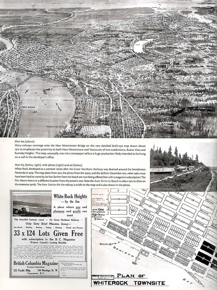
He first became interested in geography through his childhood hobby of stamp collecting in his English hometown of Eastbourne, Sussex – a seaside town he notes is remarkably similar to White Rock in its atmosphere, pier and concentration of older people.
After training as a geographer at the University of Hull, he came to UBC to do graduate work in the Geography department in 1969 – and stayed in B.C.
An interest in botanical geography led him to become an importer of hobby greenhouses, and then the distributor and publisher of gardening books.
He published his first Historical Atlas of British Columbia and the Pacific Northwest himself – it seemed logical when, at the time, he had an established distribution network and warehousing.
“When I did the first book, I didn’t know if anyone would be interested in a book of maps, but it sold really well. It created for me a little niche, almost, in the market.”
Hayes notes that the new book is not a reworking of the first, now out of print.
Indeed, the new work collects a staggering 900 maps that he has reproduced from sources in Canada, Britain and as far afield as Spain and Russia, only 30 of which were published before.
In each historic map, Hayes traces not only features of a landscape but the psychological tenor of the times that produced it. Each name of a settlement, a road, a river or a region – even the ones that did not stick for one reason or other – carries with it a story he is happy to tell.
And even errors and omissions in old maps, he has found, constitute valuable clues to what happened in the past.
“It tells you what they didn’t know – which to a large extent governed their actions,” he said. “For example, Alexander Mackenzie made the first overland trip to B.C. partly because he thought he was much closer to the coast, based on the stories of other fur traders, than he was. He was even carrying a message for the Empress of Russia when he ended up in what is now Bella Coola.”
The latest atlas offers its own fascinating journey with a plethora of intriguing stops and side-trips. For instance, how many today know that the boundary between the U.S. and Canada was arbitrated by the German Kaiser in 1872, or that, due to a surveying error, half of the present day city of Blaine, Wash. sits on what should be, by rights, Canadian territory? (Regarding the latter, it took another treaty, in 1908, to formalize the erroneous border where it sits in Peace Arch Park.)
Canada could have been even bigger, Hayes said.
“In the 1820s, the Americans offered us a border that would have taken Canada down to the outskirts of Everett, Wash.” Hayes said. “They were turned down, but that was only because, at that time, we thought we could have even more.”
Other tidbits of long-forgotten history recalled through Hayes’ explorations include the long-forgotten massacre of wagon-road construction workers by the Tsilhqot’in (then known as Chilcotin) people in 1864, angered and fearful at the spread of smallpox in their community.
And it just might be news to most current drivers that, up until 1920, everyone drove on the left in the province – one of the elements underlining the ‘British’ in British Columbia.